- What it is
- An incorporated city of its own, roughly 118 square miles of it, on the south-east side of the Las Vegas Valley. Not a neighborhood and not a master plan.
- Known for
- Range. Green Valley's grown-in streets, hillside estates in the south, a lake in the north-east, a historic downtown, and the valley's busiest industrial growth front in the west.
- Major corridors
- I-11 · I-215 · I-15 · St. Rose Pkwy · Boulder Hwy · Lake Mead Pkwy · Horizon Ridge
- Names you'll hear
- Green Valley · Green Valley RanchAnthem · Seven HillsInspirada · West HendersonCadence · Lake Las VegasMacDonald Highlands · Ascaya
Las Vegas Area Guide
When somebody moving to Las Vegas tells me they're looking in Henderson, I've learned not to start showing them houses. I ask a question back first, and it's always the same one.
Which Henderson? Because Henderson is not a neighborhood and it is not a master-planned community. It is an incorporated city, Nevada’s second largest, and the city puts its own area at nearly 118.5 square miles. It has its own mayor, its own council, its own police and fire departments and its own parks department. Summerlin is about 35 square miles. Henderson is more than three times that.
Inside that line you’ll find streets that opened in 1978 with trees you can walk under, a 1940s main street built for a wartime magnesium plant, custom lots blasted into a hillside, a man-made lake with resorts on it, age-restricted golf communities, brand-new townhomes, and a 2.4 million square foot factory going up on the far western edge. All the same city. All genuinely Henderson.
So this guide does the thing the listing sites skip. Where the city actually is and where it actually ends, what its parts are called, why two of the most common Henderson names get mixed up constantly, what’s being built right now, and what changes about your day depending on which corner you land in.
Henderson, Nevada Map
When somebody says Henderson, where are these places actually?
Look at the shape before you look at anything else. Henderson runs roughly 17.6 miles east to west against 16.1 miles north to south, it reaches west across I-15 to Las Vegas Boulevard, and it pushes a long arm south-east through empty desert toward Railroad Pass. That is not the tidy square people picture when they say “Henderson.”
Now look at the distance between Lake Las Vegas in the top right and Inspirada in the bottom left. Those two sit in the same city and answer to the same council, and they are about sixteen miles apart in a straight line, which is further than Summerlin is from the Strip. A buyer choosing between them is not choosing between two neighborhoods. They’re choosing between two completely different lives.
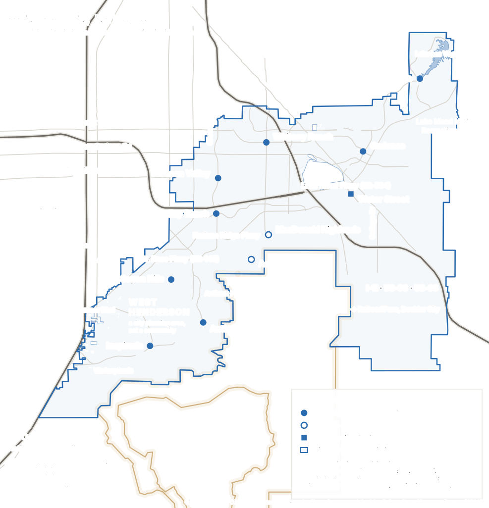
What's on this map
- The blue outline
- The real City of Henderson boundary, from the city's own GIS. Everything inside it is Henderson; everything outside it isn't, whatever the mailing address says.
- The gaps inside the outline
- Unincorporated Clark County pockets the city grew around without annexing. There are 22 of them; all are cut out of the shape, but only the four big enough to read are outlined.
- Green Valley and Green Valley Ranch
- The established middle of the city, west of Water Street. Green Valley is the original 1978 master plan; Green Valley Ranch is a newer community inside its boundaries, not a synonym for it.
- Seven Hills and Anthem
- The southern hillsides, climbing toward the McCullough Range. Elevation, views, and the longest drives to the rest of the valley.
- MacDonald Highlands and Ascaya
- Marked with open circles rather than solid dots, because they are custom-home developments rather than master-planned communities. Different kind of thing, different kind of purchase.
- Inspirada and West Henderson
- The city's growth front. Inspirada is a community; West Henderson is a City of Henderson planning area, which is why it gets a label and no marker.
- Water Street
- A square rather than a circle: this is Henderson's downtown commercial district, the original town, not a residential community.
- Cadence and Lake Las Vegas
- The eastern half. Cadence is the newest large master plan; Lake Las Vegas sits further north-east around a man-made lake and functions almost as its own place.
- I-11 (with US-93 and US-95)
- The freeway spine, running north-west to south-east across the city toward Railroad Pass and Boulder City. It was signed I-515 until 2024.
- I-215
- Crosses the northern end of Henderson and connects west toward the airport and I-15. The stretch between Pecos and Stephanie is being widened right now.
- Sloan Canyon National Conservation Area
- The gold line along the south. Federal BLM land, and the reason Henderson stops climbing into the McCullough Range.
- Las Vegas Boulevard
- Drawn but not labeled. It runs parallel to I-15 and only about twenty pixels from it at this scale, so a label could not honestly say which road it belonged to.
This boundary is the real one. Henderson is an incorporated city, so unlike Summerlin it has a genuine public line, and there was no excuse for approximating it. The outline comes from the City of Henderson’s own GIS city-boundary layer, published through the city’s open-data portal, requested in WGS84 and drawn without smoothing. No ZIP-code boundary, MLS area or hand-drawn blob was used or substituted. The polygon measures 121.96 square miles, slightly more than the “nearly 118.5” the city quotes on its fact sheet; both are the city’s own numbers, from different vintages, and we’re not going to average them into a third one that nobody published. A few more names (Tuscany, Sun City Anthem, Anthem Country Club, Sun City MacDonald Ranch, Calico Ridge, Mission Hills, Madeira Canyon) are covered in the communities section rather than lettered onto the drawing, because a map you can read beats one that lists everything. Roads, the Sloan Canyon boundary and the lake come from OpenStreetMap.
Where Henderson actually is
Henderson occupies the south-eastern corner of the Las Vegas Valley, between the Las Vegas city limits and unincorporated county on one side and the McCullough Range, Sloan Canyon and Lake Mead on the other. The city describes itself as sitting on the southern rim of the valley, and the shape follows the terrain: it spreads sideways because the mountains stop it going south, and the federal land around Lake Mead stops it going east.
It is a city, and that is not a technicality
Henderson was incorporated on 16 April 1953, and it exists because of the Second World War. Around 2,700 workers began building the Basic Magnesium plant in September 1941; when it opened the following February it drew roughly 15,000 people, and at its peak it produced about a quarter of the nation’s magnesium. The town grew up around the plant. Everything else in this guide was built later, on top of that.
Practically, being a separate city means Henderson runs its own police and fire departments, its own parks department, its own building permits and its own zoning. When something goes wrong with a road, a permit or a code question, you call Henderson, not Clark County and not Las Vegas. It also means the boundary is a real legal line rather than a marketing one, which brings us to the thing that trips people up.
A Henderson address is not the same as the City of Henderson
Postal addresses follow delivery routes, not city limits, and in the south valley the two diverge in both directions. Southern Highlands, Silverado Ranch and Harry Reid International Airport all sit outside the city despite being close to it and often discussed alongside it. Meanwhile the M Resort, which nearly everyone assumes is unincorporated county out on Las Vegas Boulevard, is inside the Henderson city limits. Every marker on the map above was checked against the city’s own boundary polygon before it was plotted, which is how we know.
This matters when it matters: which city issues your permits, which police department answers, which parks system you pay into and use, and which city’s rules apply to what you can build. If any of that is relevant to you, check the address against the city’s GIS rather than the envelope.
There are 22 holes in the city
The official boundary is not a simple outline. It is one outer ring with 22 interior rings cut out of it: pockets of unincorporated Clark County that the city grew around without ever annexing. All 22 are cut out of the shape on the map above, so the area it encloses is exactly the city’s, but only the four large enough to see are outlined. The rest are a few hundred feet across and sit below what a map of a whole city can draw.
Why you won’t find one drive time here
Every page about Henderson wants to tell you it’s twenty minutes to the Strip. Ours used to say something similar. The number is meaningless across a city seventeen miles wide. A home on Las Vegas Boulevard at the western edge and a home at Lake Las Vegas are separated by most of Henderson before either of them gets anywhere, and the answer changes again with the hour, the direction, and which of the two major road projects currently dug into the city is in your way. Pick the address you’re actually considering, and drive it at the hour you’d actually be driving.
Five Hendersons: my shorthand, not the city's
Henderson has no official sub-regions. The city doesn’t publish a list of districts and there is no council-defined taxonomy to hand you. What follows is an LVINIT way of organizing the city, not a government one. It exists because it’s how the place actually sorts itself when you drive it, and because each group was built in a different decade, which you can see from the car.
1. Historic Henderson and Water Street
The original town, in the middle-east of the city. This is where Henderson started, around the magnesium plant, and it has the only pre-master-plan bones in the city: a real main street, civic buildings, older and smaller housing stock, and a walkable core that grew rather than being designed. The city’s redevelopment agency has been working on it since 1995 and it is visibly still changing — most recently with a newly announced plan for the long-empty former Fiesta Henderson casino site at its western edge, and with the district’s own bankruptcy-to-foreclosure saga at its newest apartment building.
2. The Green Valley core
The established middle, and the part most people actually mean when they say Henderson. Green Valley opened in 1978 as Southern Nevada’s first master-planned community, twelve years before Summerlin broke ground. Green Valley Ranch, Green Valley South and Whitney Ranch sit in and around it. This is resale territory with mature landscaping, and it is the shortest run from Henderson to the rest of the valley.
3. The southern hillsides
Everything climbing toward the McCullough Range: Seven Hills, Anthem, MacDonald Highlands, Ascaya, Sun City Anthem. Mostly late 1990s and 2000s, with custom hillside development continuing today. The land starts moving, the streets stop running on a grid, the views get long, and everything you need is downhill and a drive. This is also where Henderson’s guard gates and its highest prices are.
4. West Henderson
The growth front, west and south of St. Rose Parkway. West Henderson is a City of Henderson planning area, not a community, which is why it appears on the map as a label with no marker. Its Land Use Plan was approved by City Council in December 2014. Inspirada is the big residential community inside it; the rest is the city’s push to become somewhere people work rather than somewhere they drive home to, and it is where the newest construction and the newest jobs both are. The newest amenity is Henderson Sport & Social, a 180,000-square-foot sports and entertainment complex at St. Rose and Maryland Parkways that soft-opened in October 2026 (grand opening weekend October 16–17) — our guide has the full tour, prices and hours.
5. The eastern half
Cadence and Lake Las Vegas, plus the Boulder Highway corridor running between them. Cadence and Aries are the newest large master plans on this side, and Aries, on the former Three Kids Mine site south of Lake Las Vegas, only opened in September 2026. Lake Las Vegas is further out again, past several miles of open desert, and functions almost as its own place. This half of the city is closest to Lake Mead and furthest from everything on the west side of the valley.
A word of caution on those five: they are useful shorthand, not categories with legal force. Nobody in Henderson city government will know what you mean by “the southern hillsides.” What they will know is the community name, which is exactly why the next section is organized by those instead.
The communities people actually mean
Not every named community in Henderson is here, and a few smaller ones are grouped into the sections above, but these are the names you’ll actually hear, where they sit, and what separates them from each other. Note that they are not all the same kind of thing: some are master plans, two are custom-home developments, and one is a downtown.
Green Valley
West-central Henderson, around Green Valley Pkwy between I-215 and Horizon Ridge Pkwy
Southern Nevada's first master-planned community, and it beat Summerlin to it by twelve years. American Nevada Corporation started planning in 1973 and held the grand opening on 24 October 1978. The master community covers 8,400 acres, which makes it larger than several whole cities elsewhere.
- Housing
- Almost entirely resale, mostly late 1970s through the 1990s, from modest single-story homes to gated custom pockets. The trees are the tell: this is one of the few parts of the valley with genuine canopy over the sidewalk.
- What makes it different
- Age. Nothing else in Henderson has had forty-eight years of irrigation, and it shows on every street.
The place to start if you want a finished, grown-in street and don't need the house to be new. Also the shortest run from Henderson to the middle of the valley.
Green Valley Ranch
South of Green Valley proper, around Paseo Verde Pkwy and Green Valley Pkwy
A newer community inside the Green Valley master community's boundaries, begun in 1994. People use the two names interchangeably and they are not interchangeable: Green Valley Ranch is a part of Green Valley, roughly sixteen years younger.
- Housing
- 1990s and 2000s single-family, with gated enclaves, attached product and some larger custom homes on the higher ground toward Anthem.
- What makes it different
- The District at Green Valley Ranch, an open-air center that gives this part of Henderson something close to a walkable evening. Lee's Family Forum, home to the Henderson Silver Knights, sits nearby.
Worth a look if you want established streets but newer construction than Green Valley proper, and want shops and restaurants within a short drive rather than a long one.
Whitney Ranch
Northern Henderson, near Galleria Dr and Boulder Hwy
An older residential area at the northern end of the city, closer to the Las Vegas side than most of Henderson and often overlooked in favor of the bigger names further south.
- Housing
- Predominantly older resale single-family, generally at the more accessible end of the Henderson range, with newer infill scattered through it.
- What makes it different
- Position. It is the part of Henderson that behaves most like east Las Vegas, and it sits right on the Boulder Highway corridor that is being rebuilt.
Relevant if your life is anchored toward central or east Las Vegas and you want a Henderson address without the drive from the southern hillsides.
Seven Hills
Southern Henderson, west of Anthem, around Seven Hills Dr and St. Rose Pkwy
A hillside master-planned community begun in the 1990s on rising ground above the valley floor, with gated and non-gated neighborhoods side by side.
- Housing
- Largely late-1990s and 2000s single-family, a wide spread of sizes, with guard-gated custom pockets at the upper end and view lots on the higher streets.
- What makes it different
- It is the transition. Below it the valley floor is flat and gridded; above it the streets start bending around terrain. You can feel the change through the steering wheel.
Worth seeing if you want elevation and a view without going to the top of the price range, and don't mind that everything else is downhill and a drive.
Anthem
The far south of the city, against the McCullough Range
Del Webb's Henderson project, opened in 1998. 2,535 acres were approved in November 1997 and a 1999 land exchange with the BLM added about the same again, taking it past 5,000 acres, planned at 11,000 to 13,000 homes. Crucially, 'Anthem' covers three quite different subdivisions: Anthem Country Club, Sun City Anthem and Coventry Homes at Anthem.
- Housing
- Everything from production single-family to guard-gated country-club homes. Sun City Anthem is age-restricted housing with its own facilities and rules, entirely separate from the rest.
- What makes it different
- Elevation, and the ambiguity of the name. Ask which Anthem someone means before you look at anything, because the three parts are not remotely the same purchase.
For view lots and hillside living, and for anyone specifically looking at age-restricted housing. Accept that you are as far from the rest of the valley as Henderson gets.
Inspirada
West Henderson, south of St. Rose Pkwy along Via Inspirada
One of the two newest large master plans in the city, laid out around parks and a village street pattern rather than the long cul-de-sac loops of 1990s Henderson. It sits inside the city's West Henderson planning area, and the city's own land use plan has a chapter devoted to an Inspirada town center.
- Housing
- New and recent construction, a genuine mix of detached single-family, attached homes and townhomes, at higher density than older Henderson.
- What makes it different
- Street design and parks. It reads more like a walkable neighborhood plan than the rest of southern Henderson, and it is the closest large residential community to the city's employment corridor.
The one to see if you want recent construction, don't need a large lot, and want to be near where the jobs are actually being built rather than near where they used to be.
MacDonald Highlands
Above Horizon Ridge Pkwy, on the hillside east of Valle Verde
A guard-gated custom-home development climbing the McCullough foothills, built around DragonRidge Country Club. Not a master-planned community in the Green Valley or Cadence sense: this is homesites and custom builds.
- Housing
- Custom and semi-custom homes on hillside lots, at the top of the Henderson range, alongside remaining homesites. The Four Seasons Private Residences towers are being built here.
- What makes it different
- The view, and the elevation that buys it. It looks down over the whole valley toward the Strip, which is the entire proposition.
Relevant if you are looking at custom construction or the highest end of the resale market, and want a gate between you and the road.
Ascaya
Cut into the Black Mountain slopes, south-west of MacDonald Highlands
A custom-homesite development on benched lots blasted into the hillside, sold as land rather than houses. Architecturally it is the most unusual thing in Henderson, and it is deliberately small.
- Housing
- Custom homes only, mostly contemporary desert architecture, on large graded lots. There is no production housing here at all.
- What makes it different
- It is not a neighborhood you move into so much as a set of lots you build on. That is a different timeline, a different budget and a different process.
Only if you intend to build. If you want to buy a finished house, this is the wrong list.
Water Street District
Central-east Henderson, along Water Street south of Lake Mead Pkwy
Henderson's original downtown, and the reason there is a Henderson at all. The town grew up around the Basic Magnesium plant during the Second World War, and this was its main street. It sits inside the city's Downtown Redevelopment Area, and new apartment and mixed-use projects have been arriving on it.
- Housing
- Older, smaller homes on the surrounding streets, plus newer apartment and mixed-use projects arriving on and around Water Street itself.
- What makes it different
- It is the only part of Henderson with pre-master-plan bones: a real main street, civic buildings, older housing stock and a walkable core, rather than a designed one.
Worth a look if you want the oldest and most conventionally urban part of the city, and are interested in an area that is still visibly changing.
Cadence
Eastern Henderson, north of Lake Mead Pkwy around Boulder Hwy
The other new-generation master plan, on the east side of the city, organized around a central park the community describes as nearly 50 acres, with trails and pools through it. Still actively selling across a long list of builders.
- Housing
- New construction across a wide range, from attached and townhome product through to larger single-family, plus a significant rental component.
- What makes it different
- Where it is. Cadence puts you on the eastern side of Henderson, close to Water Street and Lake Mead Parkway and a long way from Summerlin, which is either exactly right or exactly wrong for you.
The east-side answer to Inspirada. Worth comparing the two directly, because they are similar products in genuinely different parts of the city.
Lake Las Vegas
The far north-east of the city, off Lake Mead Pkwy toward Lake Mead
A 320-acre man-made reservoir with a 3,592-acre developed area around it, filled from 1991 through the old wartime BMI pipeline. It went through Chapter 11 in 2008 and came out in 2010, and has been building steadily since.
- Housing
- Everything from lakefront condos and villages of attached homes to golf-course frontage, custom lots and age-restricted neighborhoods, most of it gated.
- What makes it different
- It is separated from the rest of Henderson by several miles of open desert, which is the whole point for the people who choose it and the whole problem for the people who don't.
Worth understanding on its own terms rather than as 'Henderson'. Look here if the setting and the pace are the reason you are moving, and drive the trip out at least once before you commit.
Several of these deserve their own full guide, and will get one. Until a guide is actually written the name stays plain text rather than a link. No dead ends. Dates, acreages and developer history are sourced below; the read on what each one is like is mine. Tuscany, Sun City Anthem, Anthem Country Club, Sun City MacDonald Ranch, Calico Ridge, Mission Hills and Madeira Canyon are real Henderson names too, left out here only for length.
What it actually feels like to drive
Drive from Water Street out to Inspirada and then up to Ascaya and you cross about eighty years of building in under an hour. Here’s what changes on the way.
The trees appear and vanish. This is the most reliable tell in the valley. Green Valley has been irrigated since 1978 and has real canopy over the sidewalk, which almost nowhere else in Southern Nevada can say. Inspirada and Cadence have staked saplings in gravel. That gap is decades wide and no amount of money closes it faster.
The ground starts moving. North and central Henderson is valley floor on a grid. South of Horizon Ridge the land climbs, the streets start following contours instead of section lines, and you start seeing retaining walls, benched lots and driveways with a real slope on them. At Ascaya the lots were blasted into the hillside, which is about as far from a grid as this valley gets.
The gaps between things get longer. In Green Valley, everything is four minutes away. Out toward Lake Las Vegas you drive past the last stoplight and then keep driving. That stretch of empty desert is the single most underestimated thing about Henderson, and the only way to understand it is to sit through it once.
The street pattern changes era by era. The 1990s and 2000s parts of Henderson are long collector roads and deep cul-de-sac loops behind walls. Inspirada was laid out later and reads more like a village grid with parks in it. Water Street is older than both and just has streets. Same city, three different theories of how a neighborhood should work.
And walkability is a pocket, not a property of the place. The District at Green Valley Ranch and Water Street are both genuinely walkable once you’re there. Almost nowhere else is. For most of Henderson, “walkable” means you drive, park, and then walk around, which is a perfectly good evening and a completely different thing.
Lake Las Vegas and Inspirada share a mayor, a council and a police department. They also share about sixteen miles of desert.
What the housing is actually like
Henderson has a reputation as the expensive, established option, and like most reputations it is true of part of the city and misleading about the rest. The honest version is that Henderson contains a wider range of housing than any other single name in this valley, because it is not a product, it is a jurisdiction.
Resale versus new is the first fork. Green Valley, Green Valley Ranch, Whitney Ranch and most of Seven Hills are resale only, and what you buy is a finished street, mature landscaping and a house that’s twenty to forty-eight years old. Inspirada, Cadence and parts of Lake Las Vegas are where the new construction is, and what you buy there is current spec, a warranty, and a few years of living next to a construction site. Both are legitimate. They are priced differently for reasons that have nothing to do with which is better.
The top and the bottom of the range are further apart than people expect. Older single-story homes on the Boulder Highway side of the city and custom homesites at Ascaya are both Henderson. So are attached townhomes in Inspirada, lakefront condos at Lake Las Vegas, golf-course frontage at Anthem Country Club and 1980s tract homes in Green Valley. Any average across that describes nothing.
Gates and golf shape whole areas. Guard-gated is common at the upper end: MacDonald Highlands, Anthem Country Club, parts of Seven Hills, much of Lake Las Vegas. The city’s own fact sheet lists ten golf courses in Henderson, municipal, public and private, and several of them anchor their own housing markets.
Age-restricted housing is a real category here, not a hint. Sun City Anthem and Sun City MacDonald Ranch are legally age-restricted products with their own facilities, rules and associations. That is a fact about the housing, and it is worth knowing it exists because it shapes whole sections of the southern hillsides. Whether it’s relevant to you is entirely your call.
Expect at least two layers of association, and check both. Most Henderson communities have a master association plus a sub-association, and gated or golf communities add more on top. The total varies enormously between communities and between neighborhoods inside one community. Ask for the actual figure on the actual address, not a range.
On prices, and why there isn’t a number here
I’m not going to publish an “average Henderson home price.” You’ve just read that one city contains age-restricted condos and hillside homesites sold by the lot. A single median across that range describes nothing, and it moves depending on whether whoever calculated it included Lake Las Vegas, or Ascaya, or the new-build closings in Cadence, and almost nobody says which they did.
What is worth reading is the valley-wide figure, which I keep current in the monthly market read, the new-construction read if you’re looking at Inspirada or Cadence, and a concrete walkthrough of what a specific budget buys in the $500K guide. For Henderson specifically, the honest answer is a conversation against current listings in the community you’re actually considering.
Getting around, and why it depends
This section matters more in Henderson than in Summerlin or the Southwest, because the city is big enough that two Henderson addresses can have genuinely opposite commutes. Start with the names, because several of them changed recently and a lot of pages haven’t caught up.
The freeway is I-11 now, not I-515
The main freeway through Henderson carries I-11, running concurrently with US-93 and US-95. I-11 was extended through the Las Vegas Valley in May 2024 and I-515 was decommissioned at that point. Plenty of maps, signs and websites still say I-515, including the city’s own fact sheet. They mean the same road. It runs north-west to south-east across the city, out past Railroad Pass toward Boulder City and eventually the Hoover Dam bridge.
The beltway across northern Henderson is I-215. Only the western leg, over on the Summerlin side, is the county-maintained CC-215. The other names worth knowing are all state routes: St. Rose Parkway is SR-146, Boulder Highway is SR-582, and Lake Mead Parkway is SR-564.
Two major projects are dug into the city right now
Reimagine Boulder Highway is rebuilding 7.52 miles of Boulder Highway, cutting it from six lanes to four and adding center-running transit lanes, protected bike lanes and wider sidewalks. The Henderson 215 Project is adding two lanes each way to I-215 between Pecos and Stephanie, with a diverging diamond interchange at Green Valley Parkway. Both are detailed further down. Between them they affect the two roads most of central and northern Henderson uses to leave.
Where you land changes the answer completely
Green Valley and Whitney Ranch have the most ways out: I-215 across the top, I-11 on the east, and the shortest run of anywhere in Henderson to the airport, the Strip and the eastern side of Las Vegas. West Henderson and Inspirada hang off St. Rose Parkway and I-15, which points them at the Southwest valley and the south Strip rather than at central Las Vegas.
The southern hillsides add real driving time to everything. From Anthem you are getting down the hill before you start, and Sloan Canyon means there is no southern route out. And Lake Las Vegas is its own category: several miles of open desert between it and the rest of the city, on Lake Mead Parkway, with the practical consequence that spontaneous trips into town mostly stop happening.
The one thing that is true almost everywhere in Henderson: getting to Summerlin or the northwest valley is a long trip. They are at opposite corners of the same valley, and no part of Henderson is close to any part of Summerlin. If your work or your people are on the west side, that arithmetic should happen before you fall for a house.
One more correction worth making, because it comes up weekly: Harry Reid International Airport is not in Henderson. It is in Paradise. Most of Henderson is genuinely convenient to it, which is probably where the confusion started. Henderson does have its own airport, Henderson Executive, off St. Rose Parkway, but it handles general aviation rather than commercial flights.
Parks, trails and what's outside the city
Henderson runs its own parks department and publishes its own numbers: 76 city parks including five school parks, nearly 1,400 acres of developed parks and trails, and more than 300 miles of multi-use trails, plus eleven aquatic facilities across six locations and seven skate parks.
Worth being precise about what that means, though. Henderson’s trail network was assembled over decades by a city, not designed into the arroyos from the start the way Summerlin’s was. The result is a lot of genuinely good local trail, unevenly distributed. Which of those 300 miles you actually have depends heavily on where you land, and the Pittman Wash and River Mountains corridors are worth walking before you assume.
Sloan Canyon, and a closure to know about
The Sloan Canyon National Conservation Area covers 48,438 acres of BLM land along Henderson’s southern edge, and it is the reason the city stops climbing into the McCullough Range. Its centerpiece is Petroglyph Canyon, which holds more than 300 rock art panels with around 1,700 individual design elements. It is day-use only.
If trail access to Sloan Canyon is part of why you’re looking at Anthem or the southern hillsides, check before you drive out: Nawghaw Poa Road and its parking area are closed from 12 November 2024 to 11 November 2026 while the BLM builds a permanent visitor contact station. The Petroglyph Canyon and 101 trails have been rerouted and parking has moved to Democracy Drive.
Lake Mead is genuinely close, from part of the city
The Lake Mead National Recreation Area sits immediately east of Henderson, and from the eastern half of the city, Cadence and Lake Las Vegas especially, it changes what a weekend looks like. From Inspirada or the western edge it is most of the way across the city first. Same caveat as everything else here: proximity to Lake Mead is a real Henderson advantage and it is not evenly distributed.
Closer to home, the city’s more unusual public spaces are worth knowing about: the Henderson Bird Viewing Preserve, Whitney Mesa Nature Preserve and the Acacia Demonstration Gardens are all city facilities and all a long way from what people expect a desert suburb to have.
Henderson Development Watch
Updated September 2026
Henderson changes faster than most pages about it can keep up with, and a lot of what you’ll find searching is an announcement from three years ago being recycled as news. Here’s where things actually stand, split by what’s genuinely open, what’s genuinely being built, and what has only been proposed. Every status below is sourced, and if I couldn’t verify which of the three a project was in, it isn’t here.
Open now
Built, operating, and something you can go stand in today.
West Henderson Hospital
Open1155 Raiders Way, off St. Rose Pkwy in West Henderson
A 150-bed acute care hospital that opened in December 2024, part of The Valley Health System. Before it, the western side of the city had no hospital of its own. That is the kind of thing that changes what living out there actually involves.
Status via West Henderson Hospital
Cadence Crossing Casino
Open920 N Boulder Hwy, at the edge of the Cadence community
Boyd Gaming's first new property in about twenty years, opened 25 March 2026 with more than 450 slot machines, two restaurants, a bar and a lounge. It replaced the old Jokers Wild next door. Boyd has said a hotel may follow.
Status via Las Vegas Review-Journal, 25 March 2026
M Resort second hotel tower
Open12300 S Las Vegas Blvd, at the western edge of the city
A roughly $206 million expansion that opened on 1 December 2025 and took the property to 765 rooms and suites, with a new ballroom that opened that October. Worth knowing mostly as a geography lesson: the M is inside Henderson city limits, which surprises almost everyone.
Status via PENN Entertainment
Under construction
Ground has actually been broken. Dates still move.
Reimagine Boulder Highway
Under constructionBoulder Hwy, from Wagonwheel Dr north 7.52 miles to Tulip Falls Dr
A City of Henderson and RTC rebuild of the corridor: travel lanes cut from six to four, center-running bus transit lanes, raised and buffered bike lanes, widened sidewalks, signalized mid-block crossings and new lighting. Work started in summer 2024. New streetlights are already on along part of the corridor.
Reported at roughly $185 million with completion scheduled for August 2027. If you are looking at anything along Boulder Highway, drive it before you decide.
Status via City of Henderson, current projects
The Henderson 215 Project
Under constructionI-215 between Pecos Rd and Stephanie St
Two extra lanes in each direction, rebuilt ramps, and extra turn lanes at Pecos, Green Valley Pkwy, Valle Verde and Stephanie. It also converts the Green Valley Pkwy bridge into a diverging diamond interchange and adds a pedestrian bridge over Green Valley Pkwy at Village Walk Dr, linking the two halves of The District.
The published schedule runs from the second quarter of 2025 to the second quarter of 2028, with the diverging diamond itself not starting until early 2027. This is the road most of central Henderson uses to leave.
Status via Henderson 215 Project, official schedule
Haas Automation manufacturing plant
Under constructionA 234-acre site in West Henderson
A 2.4 million square foot plant for the largest US maker of CNC machine tools, which broke ground in fall 2024. It is the anchor of the city's push to make West Henderson an employment center rather than a bedroom suburb, and it is the clearest single reason that side of the city is changing.
Reporting has put the start of operations around the end of 2026. The project has already been pushed back once from an earlier target, so treat any specific date carefully.
Status via Nevada Business Magazine, October 2024
Henderson Sport & Social
Under construction3375 St. Rose Pkwy, at St. Rose and Maryland Pkwy in West Henderson
A 180,000 square foot, two-level indoor sports and entertainment venue, built as a public-private partnership between the city and KemperSports at a total cost of about $70 million (the city funded $60 million, KemperSports $10 million). It broke ground on 21 May 2025 as the West Henderson Fieldhouse and was renamed Henderson Sport & Social in June 2026. Courts, turf fields, a fitness center, 20 bowling lanes, laser tag, mini golf and a restaurant are open to the public with no membership required.
A soft opening is set for 5 October 2026, with the grand opening confirmed for Friday, 16 October 2026. Still counted as under construction here until that date actually arrives. Full LVINIT coverage: the Henderson Sport & Social opening guide.
Status via Nevada Business Magazine, September 2026
Four Seasons Private Residences
Under constructionMacDonald Highlands, above Horizon Ridge Pkwy
Two residential towers plus custom single-family homes on the hillside, on one of the highest sites in MacDonald Highlands. Vertical construction is under way on both towers.
Unit counts, pricing and completion dates vary between sources and are largely developer marketing. Our own closer look is linked below, and it deliberately publishes none of those numbers.
Status via Las Vegas Review-Journal, December 2025
Sloan Canyon visitor contact station
Under constructionNawghaw Poa Rd, at the southern edge of Anthem
The BLM is building a permanent visitor contact station for the conservation area. Nawghaw Poa Road and the parking at the end of it are closed while it happens, the Petroglyph Canyon and 101 trails have been rerouted, and parking has moved to Democracy Drive.
The published closure runs 12 November 2024 to 11 November 2026. If trail access to Sloan Canyon is part of why you are looking at southern Henderson, check the BLM page before you drive out.
Status via Bureau of Land Management
Planned or proposed
Announced, approved, or designed, but not built. Treat renderings accordingly.
Inspirada Station
PlannedA 49-acre site in west Henderson, near Inspirada
A Red Rock Resorts proposal for a casino of about 58,000 square feet with a 201-room hotel, restaurants, a food hall, a bowling center and a cinema. The Henderson Planning Commission has approved adding 14.1 acres to the site for surface parking.
Entitled and planned, not scheduled. Red Rock Resorts has not committed to a construction date, and executives have publicly said the decision on their next big project could take a while. Do not buy on the assumption this is coming.
Status via Las Vegas Review-Journal
The former Fiesta Henderson site
PlannedLake Mead Pkwy at the freeway interchange, the gateway to downtown Henderson
On 8 September 2026 the city and California developer Agora Realty & Management announced a conceptual plan for the 35-acre site: a 150,000 sq ft indoor fieldhouse (10 basketball courts, 20 volleyball courts, batting cages), outdoor sports fields, a hotel, 75,000 sq ft of retail and dining, and 30,000 sq ft of office space. Agora would buy the land from the city for $30 million, roughly what the city itself paid for it in 2022.
Agora's own leasing president called this a conceptual plan, not an approved one: costs and a timeline are still being worked out, and the purchase and development agreements still need a city council hearing. This is the site's second named developer after an earlier deal with Utah-based Woodbury Corp. fell apart in 2024–25, so treat the announcement as a real step, not a finish line. LVINIT covers the full announcement in a companion piece, linked further down this page.
Status via Las Vegas Review-Journal, 8 September 2026
The two road projects are the ones to pay attention to if you’re shopping here this year, because between them they cover the roads most of Henderson uses to leave. The city’s own current projects list is the live version. Nothing in the planned section is a promise: entitlements are not construction, and the Fiesta site in particular has already had one developer agreement lapse before this one. Our full write-up on the September 2026 announcement has the honest read on what’s actually confirmed. Statuses here were checked on 13 September 2026 and will move.
The tradeoffs
Henderson is a good answer for a lot of people. Here’s what you’re trading for it, without manufacturing complaints to look balanced.
The size is the benefit and the problem. No other single name in this valley covers as many different housing environments, for the simple reason that no other single name is a whole city. That same range is why the word is nearly useless as a search filter, and why choosing “Henderson” without choosing a part of it usually wastes a weekend.
Some of it is genuinely far from the rest of the valley. Anthem, the southern hillsides and Lake Las Vegas add real driving time to everything, and Lake Las Vegas adds it to trips inside Henderson too. That is the price of the setting, and for a lot of people it’s worth paying. Just make sure you’ve priced it.
The established areas trade newness for shade. Green Valley has been irrigated since 1978, and almost nothing else in this valley has had that long to grow in. The houses under those trees are twenty to forty-eight years old, with the roofs, systems and floor plans of their decade. You cannot have the trees and the new build in the same place. Nobody can.
The growth areas trade shade for years of construction. Inspirada, Cadence and West Henderson mean dirt haulers, phased amenities, retail that is promised and not yet built, and roads that change alignment. That is not a warning so much as a description of what an unfinished community is. Find out what’s planned for the empty land near the house before you commit, not after.
Lake Las Vegas is not a Henderson neighborhood with a lake. It is a separate resort community that happens to be inside the city limits, with its own economics, its own history including a bankruptcy, and its own relationship to the rest of the world. Evaluate it on its own terms or not at all.
And right now, there are the roads. Boulder Highway is being rebuilt through 2027 and I-215 is being widened through 2028. It will be better afterwards. It is not better now, and anyone selling you on the commute this year should be mentioning it.
Who should look here, and who shouldn't
Look at Henderson if you want to compare genuinely different housing environments without leaving one city: established and grown-in against brand-new, valley floor against hillside, master plan against old main street. Almost nowhere else in Southern Nevada lets you do that inside one jurisdiction, and if you don’t yet know what you want, that optionality is worth a lot.
Look here too if your life is anchored on the south or east side of the valley, if you want to be near the airport or the south Strip, if you want mature landscaping and don’t need a new build, or if you specifically want elevation and a long view and are willing to drive for it.
Look elsewhere if your work or your people are on the west side of the valley. From Henderson, Summerlin and the northwest are a genuinely long trip, and no amount of liking a house fixes that. Summerlin is the answer if you want one coordinated plan and Red Rock at the back door. Southwest Las Vegas is the answer if you want new construction with a shorter run to the airport and less interest in a master plan. And the Arts District is the answer if you want to walk out of your front door into something, which outside Water Street is not what Henderson does.
And if you are looking here, do the thing this whole page has been asking you to do. Pick three parts of Henderson that sound different from each other, and drive all three on the same afternoon. Green Valley, then Inspirada, then Lake Las Vegas is the version I’d suggest, in that order. You’ll feel the whole argument in about two hours, and you’ll know which Henderson you actually want. That’s a much better question than whether you want Henderson.
Henderson vs Summerlin
The comparison people make most often, and the shakiest one, because these are not the same kind of thing. Summerlin is one master-planned community with a single developer and one set of standards. Henderson is an incorporated city with many communities, many developers and a city council. Comparing them means comparing a specific thing to an average of many things. Here’s which way each dimension leans anyway, and why. No scores, because there isn’t honest data to score these on.
- One coordinated plan you can feel from the streetThirty-six years of one developer to one set of standards. Henderson is a city with a dozen developers who never had to agree with each other.
- Leans towardSummerlin
- Range of environments inside one nameA lake, a 1940s main street, hillside custom lots, age-restricted housing and an industrial employment corridor. Summerlin's range is wide but it is all one idea.
- Leans towardHenderson
- The name telling you where someone livesBoth names are vaguer than people think, but Summerlin is 35 square miles under one plan and Henderson is 118 square miles under a city council.
- Leans towardSummerlin
- Local government you can actually callHenderson has its own mayor, council, police, fire and parks department. Summerlin has a master association and two different jurisdictions depending on the address.
- Leans towardHenderson
- Trails and parks as a designed systemSummerlin's trails were built into the arroyos between villages from the start. Henderson has more than 300 miles of trail, but assembled over decades rather than planned as one network.
- Leans towardSummerlin
- Getting to Harry Reid InternationalSimple geography. Most of Henderson is closer to the airport than most of Summerlin, though Lake Las Vegas and Anthem are their own arguments.
- Leans towardHenderson
- Getting to Red Rock and the west sideEqually simple geography, in the other direction. From Henderson, Red Rock is a genuine expedition.
- Leans towardSummerlin
- A walkable eveningDowntown Summerlin and The District at Green Valley Ranch do the same job. Henderson also has Water Street, which is older and less curated.
- Leans towardBoth
- Established housing with mature landscapingGreen Valley opened in 1978, twelve years before Summerlin's first village. Its oldest streets have had longer to grow in than anything in Summerlin.
- Leans towardHenderson
- Knowing what gets built next to youOne master plan, published, with land use set. Henderson's vacant parcels answer to city zoning and a lot of different owners.
- Leans towardSummerlin
The genuinely useful version of this comparison is Summerlin against one specific Henderson community: Summerlin against Green Valley, or against Anthem, or against Cadence. Those are apples to apples. “Summerlin or Henderson” usually turns out to mean “west side or south-east side,” which is really a question about where your work and your people are. The full comparison guide goes through it properly, and the Summerlin guide is the other side in its own words.
Henderson vs Southwest Las Vegas
A less common comparison and a more useful one, because these two are closer to each other than either is to Summerlin. Both are large, loosely-defined areas on the southern half of the valley with a lot of new construction. The difference is structure.
Southwest Las Vegas is an informal name for a stretch of unincorporated Clark County with no boundary at all, filled in by many separate builders. Henderson is the opposite: a real city with a surveyed line, its own government, and communities that were planned as communities. If you want to know exactly who governs your address and what the rules are, Henderson answers that and the Southwest genuinely can’t.
Practically, the Southwest is closer to the airport and the south Strip from most points, and its new construction is scattered across infill parcels rather than concentrated in master plans. Henderson gives you more established housing to choose from, more coordinated communities, and, in West Henderson, an employment corridor the Southwest doesn’t have an equivalent of. The two overlap geographically at St. Rose Parkway, which is why buyers so often end up looking at both without realizing they’ve crossed a city line. The full Henderson vs. Southwest Las Vegas comparison goes through it properly.
Summerlin, Henderson or Southwest?
These three come up in almost every relocation conversation, and they're not three versions of the same thing. One is a master-planned community, one is a whole city, and one is an informal name for a stretch of county. This comparison walks through how differently they actually feel to live in.
Filming now. The video lands on this page when it publishes.
Henderson, answered
The questions people actually type in, answered as precisely as the facts allow, which sometimes means answering “it depends,” and saying why.
Is Henderson part of Las Vegas?
- No. Henderson is a separate incorporated city with its own mayor, city council, police department, fire department and parks department. It was incorporated on 16 April 1953 and it is Nevada’s second largest city. It shares the Las Vegas Valley with Las Vegas, North Las Vegas and a lot of unincorporated Clark County, but it is not a district or a suburb of the City of Las Vegas.
How big is Henderson?
- The city publishes nearly 118.5 square miles on its own fact sheet, with a population of 369,167 as of January 2025. Measured off the city’s GIS boundary, it runs roughly 17.6 miles east to west and 16.1 miles north to south. For comparison, Summerlin is about 35 square miles. That size difference is the reason this guide exists.
What are the best areas of Henderson?
- There isn’t an honest ranking to give you, and anyone publishing one is guessing or selling. What there is: a set of genuinely different environments. Established and grown-in points you at Green Valley. Newest construction points you at Inspirada or Cadence. Elevation and views point you at Seven Hills, Anthem, MacDonald Highlands or Ascaya. A lake and a resort pace point you at Lake Las Vegas. An older, walkable core points you at Water Street. Pick by what you actually want, not by a list.
Is Green Valley the same as Green Valley Ranch?
- No, and this catches people constantly. Green Valley is the original master community, 8,400 acres of it, opened in 1978. Green Valley Ranch is a newer community inside those boundaries, begun in 1994, and it is what most people actually mean when they say “Green Valley Ranch” in a listing. Green Valley South is a third name, begun around 1985. They are related, and they are not interchangeable.
What is West Henderson?
- A City of Henderson planning area, not a community. Its Land Use Plan was approved by City Council on 2 December 2014 and amended several times since. It covers the western side of the city and it is where most of Henderson’s current employment and industrial growth is happening, including the Haas Automation plant and West Henderson Hospital. Inspirada sits inside it. Nobody lives “in West Henderson” the way they live in Cadence.
Which Anthem do people mean?
- Ask, every time. Del Webb’s Anthem opened in 1998 and grew past 5,000 acres, and it contains three different subdivisions: Anthem Country Club, which is guard-gated country-club housing; Sun City Anthem, which is age-restricted housing with its own rules and facilities; and Coventry Homes at Anthem, which is neither. Someone saying “we’re looking in Anthem” has told you a direction and almost nothing else.
Is Lake Las Vegas actually in Henderson?
- Yes, it is inside the city limits, but it sits at the far north-eastern end of them with several miles of open desert between it and the rest of Henderson. It is a 320-acre man-made reservoir with a 3,592-acre developed area around it, filled from 1991 using the old wartime BMI pipeline. Practically speaking it functions as its own place. Treat “Henderson” and “Lake Las Vegas” as two different searches.
How far is Henderson from the Strip?
- There is no single answer, and that is the point. Henderson is about 17.6 miles wide, so a home on Las Vegas Boulevard at the western edge and a home at Lake Las Vegas are not remotely the same trip. Add the Boulder Highway rebuild and the I-215 widening, both under construction right now, and any number you read is out of date. Pick the address you are actually considering and drive it at the hour you would actually drive it.
Is Harry Reid International Airport in Henderson?
- No. Harry Reid International is in Paradise, an unincorporated town, not in the City of Henderson. Henderson does have its own airport, Henderson Executive Airport, off St. Rose Parkway, which handles general aviation rather than commercial flights. Most of Henderson is genuinely convenient to Harry Reid; it just isn’t inside the city.
Does a Henderson mailing address mean the City of Henderson?
- Not necessarily, and it works in both directions. Postal addresses follow delivery routes, not city limits. Southern Highlands, Silverado Ranch and Harry Reid International all sit outside the city despite being nearby, while the M Resort, which almost everyone assumes is unincorporated county, is inside it. If it matters for schools, permits, utilities or who answers a call, check the address against the city’s own GIS rather than the envelope.
What is the freeway through Henderson called now?
- I-11, running concurrently with US-93 and US-95. It was signed I-515 until I-11 was extended through the Las Vegas Valley in May 2024, at which point I-515 was decommissioned. Plenty of signs, maps and websites still say I-515, including some official ones. The beltway across northern Henderson is I-215; only the western leg, over on the Summerlin side, is the county-maintained CC-215.
Should I choose Henderson or Summerlin?
- It is the wrong shape of question, because they are not the same kind of thing. Summerlin is one master-planned community; Henderson is a city with many. The useful version is Summerlin against a specific Henderson community: Green Valley, Anthem, Inspirada, Cadence, Lake Las Vegas. Usually the real question underneath is west side or south-east side, which is really a question about where your work and your people are. The full comparison guide goes through it properly.
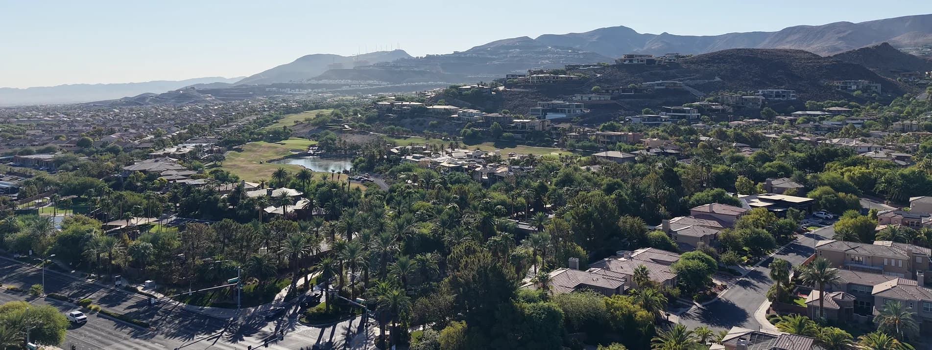
Photographed over Henderson by Mikey Del Rosario. The map on this page was built from the City of Henderson’s own GIS boundary and OpenStreetMap road geometry. Development status (what’s open, under construction, or only proposed) was checked on 27 August 2026 and will change; check with the City of Henderson, the builders or the agency involved before planning around it.
Sources & updates · Checked 27 August 2026
- City of Henderson: Fact SheetPopulation (369,167, January 2025), area (nearly 118.5 square miles), elevation, the city's own description of its topography, park and trail counts, golf courses, school and library lists, and Henderson Executive Airport.
- City of Henderson GIS: City Boundary layerThe official municipal boundary drawn on the LVINIT Henderson map, retrieved from the city's own ArcGIS Server in WGS84. The polygon measures 78,056.45 acres / 121.96 square miles and contains 22 unincorporated county pockets. Every community marker on the map was point-in-polygon tested against it.
- City of Henderson: West Henderson Land Use PlanThat West Henderson is a city planning area rather than a community, that its Land Use Plan was approved by City Council on 2 December 2014, and that it has been amended by resolution several times since.
- City of Henderson: current road projectsThe scope and limits of Reimagine Boulder Highway (7.52 miles, Wagonwheel Dr to Tulip Falls Dr), the I-215 widening, the Henderson Interchange work, and the Lake Las Vegas roundabout.
- Henderson 215 ProjectThe published construction schedule for the I-215 widening: second quarter 2025 to second quarter 2028, with the diverging diamond interchange starting in early 2027.
- City of Henderson: Fiesta Henderson siteThe status of the former Fiesta Henderson site at Lake Mead Parkway and the freeway interchange.
- Bureau of Land Management: Sloan Canyon National Conservation AreaThe conservation area's 48,438 acres, the Petroglyph Canyon rock art (more than 300 panels, 1,700 design elements), and that it is day-use only federal land.
- BLM: Sloan Canyon temporary closure noticeThe closure of Nawghaw Poa Road and its parking from 12 November 2024 to 11 November 2026 during construction of the permanent visitor contact station, and the rerouting of the Petroglyph Canyon and 101 trails to Democracy Drive.
- Wikipedia: Henderson, NevadaThe 16 April 1953 incorporation date, the Basic Magnesium history, the 2020 census population of 317,610, and the census land-area figure of 106.43 square miles.
- Wikipedia: Green Valley, HendersonThat Green Valley was Southern Nevada's first master-planned community, developed by American Nevada Corporation with planning from 1973 and a grand opening on 24 October 1978, covering 8,400 acres, and that Green Valley South and Green Valley Ranch began around 1985 and 1994.
- Wikipedia: Anthem, HendersonAnthem's Del Webb origin and 1998 opening, the 2,535 acres approved in November 1997 and the 1999 BLM exchange that took it past 5,000, the 11,000 to 13,000 planned homes, and the three subdivisions.
- Wikipedia: Lake Las VegasThe 320-acre reservoir and 3,592-acre developed area, the 1991 filling through the BMI pipeline, and the July 2008 Chapter 11 filing and July 2010 emergence.
- Wikipedia: Interstate 11That I-11 was extended through the Las Vegas Valley on 21 May 2024, that I-515 was decommissioned at that point, and that I-11 runs concurrently with US-93 and US-95.
- CadenceCadence's own description of its central park as nearly 50 acres, its amenities, and the builders currently selling there.
- West Henderson HospitalThe December 2024 opening, the 150-bed acute care designation, and that it is part of The Valley Health System.
- OpenStreetMapRoad centerlines and their official route designations, the Sloan Canyon conservation-area boundary, the Lake Las Vegas water body, and the community coordinates plotted on the LVINIT Henderson map. © OpenStreetMap contributors, made available under the Open Database License.